| The USGS Earthquake Hazards Program - NEHRP—Investing in a Safer Future |
|
|
In 1977, Congress authorized the creation of the National Earthquake Hazards Reduction Program (NEHRP) to improve the Nation’s understanding of earthquake hazards and to mitigate their effects. Earthquakes are the most costly natural hazard faced by the United States. Twenty-five years of work by the U.S. Geological Survey (USGS), in close cooperation with the three other NEHRP agencies, has yielded major advances in earthquake preparedness and monitoring, as well as a vastly improved understanding of earthquake hazards, processes, and effects. The USGS is poised to build on these accomplishments, helping through NEHRP to protect lives and property in the future earthquakes that are certain to strike the United States.
|
|
|
|
|
|
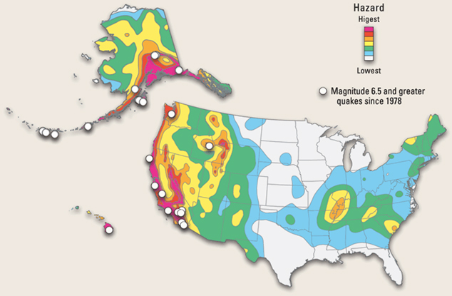
As shown by this U.S. Geological Survey (USGS) national seismic-hazard map, earthquake hazards exist throughout the United States. USGS national and regional seismic-hazard maps forecast the amount of shaking expected over specified time periods. Many parts of the Central and Eastern United States have moderate to high long-term hazard, even though they have not experienced recent large quakes. Successive updates of USGS seismic-hazard maps are used to revise building codes and are also widely used by structural engineers and government agencies. The next generation of such maps will provide time-dependent probabilities that take into account the effects of prior quake occurrence on future earthquake likelihood.
|
|
The U.S. Geological Survey (USGS) Earthquake Hazards Program monitors the Nation’s earthquakes, studies why they occur and how they shake the ground, provides quantitative earthquake-hazard assessments, helps promote loss-reduction measures using these results, and provides crucial scientific information to assist emergency responders when earthquakes occur. The USGS Earthquake Hazards Program operates under the National Earthquake Hazards Reduction Program (NEHRP), created by Congress in 1977. To meet the challenges and potential of NEHRP, activities supported by the USGS Earthquake Hazards Program are managed under four broad interrelated objectives:
- Improve quantification of seismic hazards—The USGS produces quantitative hazard-assessment products that enable the public and private sectors to assess earthquake hazards and implement effective mitigation strategies.
- Complete the modernization and expansion of real-time earthquake notification and monitoring systems—The USGS is tasked with collecting, interpreting, and disseminating information on the earthquakes that occur throughout the United States and on significant quakes worldwide in support of disaster response, earthquake preparedness, national security, scientific research, and public hazard awareness.
- Achieve better scientific understanding of earthquake processes and effects—The USGS pursues research on earthquake occurrence and effects for the purpose of developing and improving hazard-assessment methods and loss-reduction strategies.
- Provide national and local leadership to engage communities in earthquake safety practices—The USGS works with user communities to ensure that its products are readily available, easily understood, and appropriately used for earthquake mitigation and response.
The work of the USGS Earthquake Hazards Program focuses both on the Nation as a whole and also on particular regional needs and problems in areas where quake risk is the greatest. The program’s work is carried out by USGS scientific and technical personnel and also through a system of competitive external grants and contracts that is allotted one-quarter of program funds. In the past 25 years, this grants program has funded approximately 2,500 grants and cooperative agreements with state geological surveys, university researchers and research consortia, state and local government agencies, and nonprofit and other organizations in the private sector. USGS also works closely with the other NEHRP agencies (FEMA, NSF, and the National Institute of Standards and Technology) and with non-NEHRP agencies, such as NASA, NOAA, and USAID.
|
Click here
for contact information.
|